Lesson 125
29 October 1999
2.2 hours
Cross-Country on a Dreamy
Day
I flew up to Culpepper today and then to Orange and back to Chesterfield,
a distance of about 145 nautical miles, or about 170 statute miles.
The sky was absolutely cloudless and there was no wind. Once I got
aloft, though, I could see that there was some haze--not enough to make
flying difficult, but just enough to make things seem sort of dreamy.
Here you can see the horizon--the sharp line below the whitish horizontal
line. 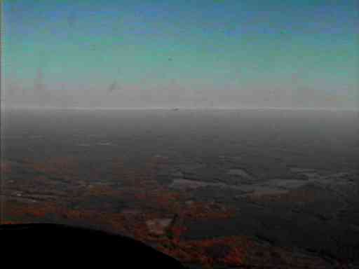 I
don't know what caused the whitish line to appear, but that happens sometimes--a
trick of the light, maybe. Above and below the whitish line is haze--a
polite name for air polution. Where the sky starts to turn blue is
the highest that the haze got today. I was flying mostly at about
2000 feet above the ground and never tried to climb up above the haze,
but I think it probably went up to about 4000 or 5000 feet. The haze
wasn't really thick. It's visible clearly here only because of the
distance--that horizon is probably at least 75 or 100 miles away, so we're
looking sideways through haze some 100 miles thick.
I
don't know what caused the whitish line to appear, but that happens sometimes--a
trick of the light, maybe. Above and below the whitish line is haze--a
polite name for air polution. Where the sky starts to turn blue is
the highest that the haze got today. I was flying mostly at about
2000 feet above the ground and never tried to climb up above the haze,
but I think it probably went up to about 4000 or 5000 feet. The haze
wasn't really thick. It's visible clearly here only because of the
distance--that horizon is probably at least 75 or 100 miles away, so we're
looking sideways through haze some 100 miles thick.
The trip was straightforward--FCI-CJR-OMH-FCI. That is, Chesterfield
to Culpepper to Orange and back to Chesterfield. CJR and OMH are
right along the western edge of the Virginia piedmont. Immediately
to their west the hills begin and beyond them is the Shenandoah Valley.
Because it had been almost a month since I last flew a 172, I did a
touch-and-go at FCI just to get back the feel of landing at a familiar
field. (Oh, well, it was really a bounce-and-go, and I got back the feel
of going around.) Then I left the pattern and headed north to Lake
Anna.
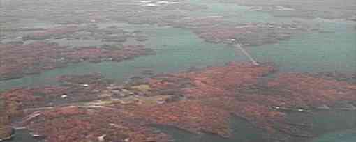
Here's a small portion of the lake. The
orange blurs are trees. The straight whitish dam-looking blur is
one of the dykes that direct water around the lake to cool.the nuclear
power plant, which is just imaginable in the blur at the top of the picture.
(Explanation of the crappy, blurred pictures.)
After admiring the lake for a while I flew on to CulpepperCounty Airport,
staying at 2000 feet MSL and below, to look at the land I was flying over.
The broadleaf trees are mostly orange and yellow now, so the forests stood
out brilliantly against the fields, roads, and all. I flew by pilotage
and managed not to get lost, even though I did a lot of flying around off
the course, admiring the scenery. I checked the GPS now and then
only to confirm that I really was on course (and sometimes to confirm that
I wasn't). I did use the GPS to find the airports when I was too low to
see them readily, and it gave me the distance and ETA to them. That was
especially helpful approaching Culpepper because I'd never been there before,
and it's a smallish field with nothing much around to help spot it.
At Culpepper I did a touch-and-go (better this time) and then headed
southwest toward Orange County Airport. My course was parallel to
the hills, and I stayed low enough so that their peaks were more to the
side than below.
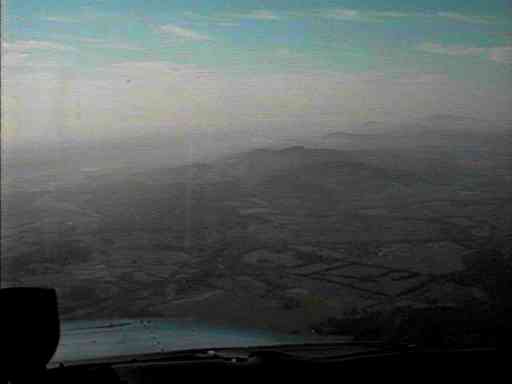 This
photo is looking southwest, after taking off from Culpepper. You
can imagine in it the beautiful fall colors, the mist-like haze, and the
hilltops sticking up through the haze. (The black thing in the lower
left corner is the airplane's magnetic compass, and the engine cowling
is the whitish thing to its right.)
This
photo is looking southwest, after taking off from Culpepper. You
can imagine in it the beautiful fall colors, the mist-like haze, and the
hilltops sticking up through the haze. (The black thing in the lower
left corner is the airplane's magnetic compass, and the engine cowling
is the whitish thing to its right.)
When I reached Orange I parked the airplane, went to the john, and strolled
around for a while, looking at some airplanes while munching on a Granola
bar. Two big hawks were flying over the approach end of the runway,
soaring into what little breeze there was, looking exactly as if they were
on short final for landing. There must have been just enough thermal
to keep them aloft at about 75 feet over the meadow just beyond the runway.
After about twenty minutes they wheeled around and soared away, so I climbed
into the 172 and headed back to Chesterfield County Airport.
There was a big fire from a slash-and-burn clearing operation near Louisa. 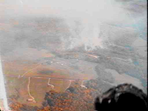
The smoke rose to about 2000 feet and completely obscured the ground
as I flew over about 500 feet above it. Even there I could smell
it. I made this shot after I had gotten downwind of the fire--but
because there was almost no wind the smoke pretty much went up in the air
and hung there. At least I could see the source of this pollution.
Back at Chesterfield, I managed a pretty good landing--maybe not exactly
grease,
but certainly the best of the four today.
This was probably the most comfortable cross-country trips I've had.
I'd allowed plenty of time, so I could just take it easy and enjoy the
day and the flying. The Hobbes meter said I'd flown for 2.2 hours,
long enough to cruise some 230 statute miles in that Cessna 172, including
taxiing, runup, and all. So I probably did about 60 statute miles
of flying around looking at things.
ABOUT THE PICTURES
I took along the camcorder, mainly to see if I could get it to record
the intercom audio. That didn't work because without thinking the
problem through quite well enough, I connected it such a way that the camera's
own mike was still hot--so all I got was engine and prop noise.
I also took along a plastic bag of split peas. Did I plan to do
a little cooking up there--get a little head start on dinner? No,
the peas were to rest the camcorder on, atop the instrument panel.
That didn't work either, but only because I chickened out, thinking that
even though there was no wind or turbulence, it still might not be such
a great idea to have several pounds of machine sitting loose up there.
The real problem was that the camera wouldn't sit far enough forward because
of the windscreen and would only just barely stay balanced on top of the
panel.
So I did a bit of videotaping with it in my hand. That didn't
work either because I forgot to set the lens to infinity, so it was even
more out of focus than usual.
Nevertheless, I was able to grab a few frames with Snappy. (They're
in here as really lo-res jpgs because they're lo-res even without the compression).
BACK TO THE STORY
Back to "Learning
Flying"
My
home page.